There is no doubt that land navigation using compass and map is a necessary skill for a prepper. However, training materials out there are either too simple or too lengthy (e.g. – military reference). Below are files of a 5 part series on land navigation from 101 to advanced. Through my research, I have found these presentations to be the most comprehensive and easy to understand.
The downloads are open source and ARE FREE to be shared across the community. So share and educate others!
Once you get comfortable doing basic navigation tasks with a compass, did you know that it can offer more than just directional finding? In the advanced series, you can learn how to use a compass to measure distance between you and an object! Very cool stuff using simple trigonometry!!
Recommended Equipment:
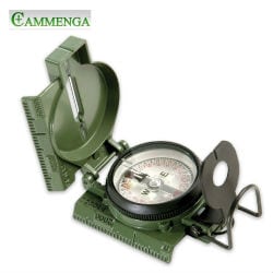
Cammenga 3H Tritium Lensatic Compass (Glows in dark without needed sunshine)
Have FUN!
Land Navigation for Beginners – 101
- Understanding a Lensatic / Military Compass
- Reading a topographic map
- Association between land and maps
LAND NAVIGATION Part 1a
LAND NAVIGATION Part 1b
Land Navigation for Intermediate – 201
- Direction finding: azimuths
- Tracking: Resection, Intersection, & UTM Grid Coordinates
- Determining distances
Land Navigation for Intermediate/Advanced – 301
- Advanced planning (staying on course)
- Navigation in a group
- Determining distances (advanced)
Drawing maps
Land Navigation for Expert – 401
- Dead Reckoning
- Navigating different terrains (snow, forest, etc.)
- Night Time Navigation
Setting up navigation courses


